The Polar Retrospective looks at recent stories from around the world’s polar regions. This week we take a look at a hidden lake flood beneath the Greenland Ice Sheet, the end of another icebreaker era in Antarctica, and traces of an ancient rift between America and Greenland.
The Polar Retrospective is a collaborative effort by the editorial team of polarjournal.net. Each writer chooses a topic they found interesting and important in the past week. The initials at the end of each section indicate the author. We hope you enjoy it.
Hidden subglacial lake drainage in Greenland forces meltwater up through the ice sheet
In the summer of 2014, a previously unknown subglacial lake beneath the Greenland Ice Sheet drained within just a few days — with significant consequences at the surface. According to an international research team reporting in Nature Geoscience, the meltwater was released with such immense pressure that it fractured the overlying ice and burst through the surface.
Satellite data show that within ten days, a crater approximately 85 meters deep formed across an area of two square kilometers. Around 90 million cubic meters of water — roughly equivalent to nine hours of peak flow over Niagara Falls — escaped from the subglacial lake.
What researchers discovered a few kilometers away was even more surprising: in an area of previously undisturbed ice, a large, severely fractured zone had suddenly formed. It covered about 385,000 square meters — the size of 54 football fields — and was marked by deep cracks and towering ice blocks up to 25 meters high. Through these fractures, water surged upward. An area spanning six square kilometers showed clear signs of surface flooding from the escaping water.
Equally noteworthy is the location of the event: in a region where models had previously assumed that the ice at the bed was frozen solid, making subglacial drainage impossible. However, the new data suggest that extreme water pressure forced open fractures along the base of the ice sheet, creating a vertical pathway to the surface. This challenges the long-standing assumption that meltwater travels only from the surface down to the base, where it drains toward the ocean.
In addition to the surface disruption, the flood event caused a temporary but rapid slowdown of a downstream, marine-terminating glacier — a clear indication of how basal hydrology and surface processes can be dynamically linked. Current models of ice sheet behavior do not account for such vertical flood events or their structural and dynamic consequences.
As surface melting increases under climate warming, these findings highlight the need to better understand the complex, two-way interactions between surface and basal water systems — and their potential to influence ice sheet stability and sea-level projections. J.H.
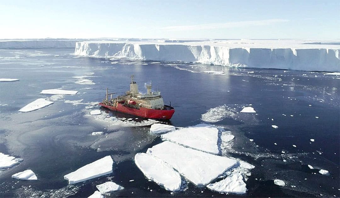
U.S. to Retire Sole Antarctic Research Icebreaker, Sparking Scientific Outcry
The U.S. National Science Foundation (NSF) plans to terminate the lease of its only Antarctic research icebreaker, the Nathaniel B. Palmer, in 2026, citing severe budget cuts and a need to prioritize its three land-based stations. The decision ends over 50 years of continuous U.S. dedicated research vessel presence in the Southern Ocean.
For three decades, the Palmer has been a critical platform for U.S. science, enabling access to remote, ice-covered regions and supporting crucial climate research, including studies of the Thwaites “doomsday glacier”. Its retirement leaves a significant capability gap.
The NSF’s proposed interim solution, redeploying the smaller Arctic vessel R/V Sikuliaq, has been deemed “wholly unsuited” by scientists due to its limited capacity and weaker icebreaking ability. A purpose-built replacement vessel is not expected until the mid-2030s, and its development funding has also been cut in the same budget proposal, creating a potential “lost decade” for U.S. polar marine science.
Over 170 scientists have signed an open letter protesting the move, warning it forecasts a decline in U.S. scientific leadership and cedes influence to competitors like China, who are expanding their Antarctic presence. The community urges Congress and the NSF to reverse the decision and fund a next-generation vessel to avert a long-term strategic and scientific void. M. W.
Beneath the Appalachians, Traces of an Ancient Rift Between America and Greenland
A thermal anomaly buried 200 km beneath the Appalachians has puzzled geologists for decades. Why is there a vast zone of abnormally hot rock in a region that has been tectonically stable for the past 180 million years? An international study, published on July 29 in the journal Geology, offers a new explanation: this anomaly, called the Northern Appalachian Anomaly (NAA), may be a remnant of a rifting event that separated Greenland from Canada roughly 80 million years ago.
According to the authors, who based their work on geodynamic modeling, seismic tomography, and tectonic reconstructions, this hot zone likely originated near the Labrador Sea and migrated slowly southwestward at a rate of about 20 kilometers per million years. Today, it lies beneath New England and could reach the New York region in 15 million years.
At the root of this phenomenon is a so-called “mantle wave,” a slow process in which blobs of hot rock detach from the base of the lithosphere and move beneath continents like bubbles in a lava lamp. These instabilities may help explain both unexpected volcanic eruptions and the uplift of ancient mountain ranges like the Appalachians. “ Heat at the base of a continent can weaken and remove part of its dense root, making the continent lighter and more buoyant, like a hot air balloon rising after dropping its ballast,” explains Tom Gernon, lead author of the study and Professor of Earth Science at the University of Southampton, in a press release.
The researchers also suggest that a “thermal twin” may lie beneath central Greenland, contributing to the warming at the base of the ice sheet and influencing its dynamics. It’s yet another reminder that the scars of Earth’s ancient ruptures still shape the geography of today from deep below. M.B.